What was the biggest weather event in our area during 2011?

Sunday, August 26, 2012

Are Texas & Oklahoma In The Ballgame For Isaac?

Good Afternoon Texoma,

I hope you all have had an amazing weekend; hopefully you picked up some rainfall too.  Let's get right to, the overnight forecast model runs have shifted the 'track' of Tropical Storm Isaac to the left-west.  A couple  reliable models are even showing potential impacts for eastern Texas & Oklahoma.  This graphic shows what the current thinking is for Isaac per forecast models.
The reasoning behind the northerly track-ECMWF, and the northwesterly track-GFS is that the ECMWF has Isaac being picked up by a trough, whereas the GFS has Isaac being caught under the ridge which will try to dominate the Southern Plains.  The 12Z GFS shows Isaac moving northwest to near NOLA, followed by a westerly track towards the southeastern Texas coast.  Once Isaac approaches the Texas Coast, per GFS, Isaac moves into northeastern Texas. (Please note that the models could shift east with the next run.  Forecast models can flip-flop more than a politician.)
Image
Isaac is currently a 65mph tropical storm with pressure down to 995mb.  Further strengthening is likely with Isaac and Hurricane Isaac is possible by this evening.  The 'track' of  Isaac will be monumental in forecasting the strength, but a Category 2 or 3 hurricane is possible.  Residents who live along the Gulf Coast from Beaumont, Texas to Pensacola, Florida need to keep a close eye on future forecasts.

Here is the official cone from the NHC and the NAVY.
NHC Cone
[Image of 5-day forecast and coastal areas under a warning or a watch]


NAVY Cone
ImageWe will have updates on Isaac as needed.  Please note that these are the thoughts of 'Texoma Weather' & www.primoweather.com.  This forecast is not official and you are encouraged to see
www.nhc.noaa.gov for official forecasts.

Friday, August 3, 2012

Tropical Storm Ernesto A Heat Buster? And Invest 90L

The tropics had been quiet over the past few weeks, but that changed quickly.  We are now watching Tropical Storm Ernesto, as well as a tropical wave in the Eastern Atlantic that has the potential to slowly develop into a Tropical Depression or Tropical Storm over the next few days.

Tropical Storm Ernest is currently moving through the Lesser Antilles-producing heavy rain and very gust winds; a 63mph gust was recorded this morning near St. Lucia.  Ernesto had weakened this morning from a 50mph storm to a 45mph storm, but as of 11:00am the storm has strengthened into a 50mph storm.  The slight weakening was caused by the quick forward motion of the storm-close to 24mph earlier this morning.  Forward motion at this speed makes it difficult for a storm to maintain its strength because it shears itself.
 
Some of the guidance was showing Ernesto opening up into Tropical Wave after it moved through the islands, which could have been shown due to the projected speed of the system.  With that said, other environmental conditions are favorable for strengthening by late this weekend.  There are two possible tracks for Ernesto which will heavily depend on the strength of Ernesto.

If Ernesto strengthens over the Caribbean, it would move poleward into the southern Gulf of Mexico as it feels a weakness over the southern part of the United States; however, if Ernesto opens up into a Tropical Wave-and stays as a wave, it could move inland over the Yucatรกn Peninsula.  I believe Ernesto will begin to strengthen over the western Caribbean, and feel the weakness which will drive it towards the southern Gulf of Mexico.  At this point, the "death ridge" over Texas and Oklahoma will build west which could direct Ernesto in our direction.

The whole Gulf Coast needs to be on alert, but at this point I think the Texas/Mexico Coast has the highest chance of seeing direct impacts from Ernesto.  By the time Ernesto makes it into the Gulf of Mexico it will likely become a Hurricane Ernesto.  There will be low shear, the SST are very warm, and the environment Ernesto will move into will be fairly moist.

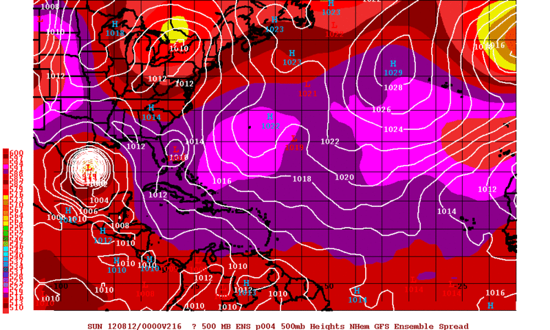
Taking a look at the latest guidance-the models are having a hard time agreeing on the strength of Ernesto which will play a pretty big role in which path Ernesto takes.  This image below is GFS Ensemble 4 which is one of the most intense solutions.  It paints a picture of Hurricane Ernesto slamming into the Texas Coast. Keep in mind this is only a model run and should be used that way.  These models can flip flop every run-just like politicians.

This is the spaghetti plot which shows the path that the models are projecting.  Notice the models agree upon a similar path over the next 48 hours.

Here are my thoughts on a possible path for Ernesto which I believe will become a Hurricane in the Gulf of Mexico.  I'm leaning towards a Texas/northern Mexico impact at this point.  This is an educated guess and the whole Gulf of Mexico needs to closely watch Ernesto.
This is the latest projected path from the NHC as of 11:00am.

If Ernesto follows my projected path, parts of Texas-possibly Oklahoma will see some heat and drought relief by next weekend.  I know many people are praying and thinking good thoughts for this to happen because we need the rain.  Let's hope no major damage is cause by Ernesto-no matter which path it takes. 

No let's take a quick look at Invest 90L which has developed in the eastern Atlantic.  This wave has developed some intense convection and if it can sustain itself then slow organization could occur which could lead to this system developing into a Tropical Storm over the next few days.  The NHC has given this system a 30% of tropical development.
We will have updates over the next several days.  Please note this forecast and these opinions are that of www.primoweather.com and not the NHC.  For official information please see http://www.nhc.noaa.gov/

Monday, July 30, 2012

Tropics: Ernesto?!

The tropics have been quiet over the past few weeks, but that appears to be changing in the near future.  We are watching a tropical wave in the Eastern Atlantic that has potential to slowly develop into a Tropical Depression or Tropical Storm over the next 3-7 days; this is also supported by several numerical models.

Invest 99L-the aforementioned tropical wave, while experiencing relatively conducive conditions for further development will have a few obstacles to overcome before any significant strengthening occurs.  This wave will have to fight of the dry Saharan air as it treks further north which will likely slow the development of the system.  (The environment the system is in now is moist.)

Another big factor is the the positioning of the wave; it's near 8-9 degrees N which is close to the equator.  This proximity to the equator will hinder the systems rotation due to the lack of the Coriolis Force-acceleration caused by the earth's rotation.

99L still has a lack of convection associated with the wave, but a slow increase in convection is likely.  (Latest water vapor satellite image, courtesy NHC)
The wind-shear remains low ahead of the system which should allow the wave to slowly organize and allow further convection to develop-and likely consolidate to form a closed surface low.  The NHC has given Invest 99L a 20% of development over the next couple of days.  (Tropical Outlook from the NHC.)
Without a developed system, we will be very vague on possible tracks for the system.  The wave will appears it will either move WNW into the Caribbean or possibly take a more NW track.  The Greater and Lesser Antilles need to keep a close eye on this system over the next few days.  Please note that this track map is www.primoweather.com's and Texoma Weather's projected path and is not the opinion of the NHC or NWS. 
We will have updates on this system over the next several days.  For official information please see http://www.nhc.noaa.gov/

Wednesday, July 25, 2012

Wet End To July!!

Texoma will be blessed with beneficial rainfall to end the month of July.  A surface cold front will move into extreme northern Oklahoma tonight which should be the focus for shower and thunderstorm development.  The convection that forms will push the front further south into Oklahoma on Thursday which will increase Texoma's rain chances.  Scattered thunderstorms should develop along the front Thursday and Friday becoming quite numerous at times; especially in southern Oklahoma.  You can see on the HPC map just how widespread the activity could become;  north Texas can expect .50-.75" while southern Oklahoma could pick up a quick 1.00-1.25".
A few storms could become strong-possibly severe on Thursday afternoon.  The main threat is damaging winds in excess of 50-75mph.  With that said, if you have any outdoor plans make sure you stay alert to Texoma Weather and www.primoweather.com for the latest updates.

Friday, July 20, 2012

Very Hot, But A 10% Chance Of Storms

Today will be another hot day across Texoma and all of the Southern Plains.  Most locations will easily exceed the 100 degree mark with a few locations topping 107. But, with that said, there is an ever so slight chance of an isolated thunderstorm this afternoon.
Thunderstorms developed in northern Oklahoma yesterday, along a diffuse boundary, and pushed south overnight.  The storms have fallen apart as of this morning, but not before a small circulation, known as an MCV, developed.  This MCV is currently over south-central Oklahoma and its pushing slowly southward.  As it treks into the Red River Counties this afternoon a couple isolated thunderstorms could develop.  Chances are about 10-15%, but if you get under a storm, expect heavy rainfall and possibly downburst winds.

Thursday, June 28, 2012

Hot, Hot, HOT!!!

I hope you all are having a great Thursday.  It has been miserably hot over the past several days, but there's a little relief in sight.  Temperatures will cool by 2-6 degrees  across Texoma tomorrow and even further by the weekend. 

The massive ridge that has been in place, which is responsible for our hot temperatures, will have a pretty subtle weakness over the weekend.  This weakness will allow a quick surge of moisture over the weekend which could allow for one or two pulse variety storms to form; most areas will stay dry.

The ridge will strengthen its grip over our area on Monday and Tuesday causing temperatures to spike once more.  Your 4th of July forecast looks hot with a slight chance for thunderstorms during the evening hours.  We will have updates over the next few days to fine tune your holiday forecast.

Also, we are keeping an eye on a tropical wave that's east of the Windward Islands for possible development over the next several days!

Friday, June 15, 2012

Earthquakes, Thunderstorms, Tornado, and Tropics!

We have a lot to talk about today, but I'll try to not to make it too wordy.  Over the past few days, several parts of Texoma have picked up very beneficial rainfall.  This rain did come with a price for some areas, especially Fannin County.  The Fort Worth National Weather Service confirms an EF0 tornado caused damage north of Randolph.  Winds were estimated around 85mph with this tornado which caused damage to several homes and barns.  Most of the damage in the County was caused by softball sized hail and 85-95mph straight line winds.  Three people were injured in this storm.

Three other predominant supercells in the DFW Metroplex caused an estimated $400 million in damage on June 13th.  Most of the damage was caused by 3-5" hail that created a winter-like scene with inches of hail piling up on the ground.

There will be a chance for thunderstorms today in north Texas and southern Oklahoma.  The scenario that will play out is unclear, but some of the models are paining a thundery scenario for the area this afternoon.  The morning convection will need to move out of the area to allow the atmosphere to recover.  It appears this will occur, and an MCV which is located in south-central Oklahoma will be the culprit for thunderstorm development this afternoon.  If storms develop, they could become severe with damaging winds and very large hail.
This morning around 2:02am there was a 3.1 earthquake between Cleburne and Fort Worth.  Many people felt the earthquake across north Texas.  The earthquake caused no injuries or damage.
A 2.5 earthquake occurred in Oklahoma yesterday too; this one was near Oklahoma City!  The quake was not felt widespread because of its low magnitude.  No injuries or damage were reported with the earthquake near OKC.
These earthquakes come just weeks after a 4.3 earthquake occurred near Timpson, Texas which caused one injury and minor damage.

Tropical troubles could be in store for Texas!!  Computer models have been consistent in developing a tropical system over the Bay of Campeche and moving it into the Gulf of Mexico.  At that point it appears the system could impact Texas; likely dumping heavy rainfall and possibly spinning up a few tornadoes.  This tropical system, if it develops, would begin to impact Texas around Friday-Saturday of next week.