Tropical Storm Ernest is currently moving through the Lesser Antilles-producing heavy rain and very gust winds; a 63mph gust was recorded this morning near St. Lucia. Ernesto had weakened this morning from a 50mph storm to a 45mph storm, but as of 11:00am the storm has strengthened into a 50mph storm. The slight weakening was caused by the quick forward motion of the storm-close to 24mph earlier this morning. Forward motion at this speed makes it difficult for a storm to maintain its strength because it shears itself.
Some of the guidance was showing Ernesto opening up into Tropical Wave after it moved through the islands, which could have been shown due to the projected speed of the system. With that said, other environmental conditions are favorable for strengthening by late this weekend. There are two possible tracks for Ernesto which will heavily depend on the strength of Ernesto.
If Ernesto strengthens over the Caribbean, it would move poleward into the southern Gulf of Mexico as it feels a weakness over the southern part of the United States; however, if Ernesto opens up into a Tropical Wave-and stays as a wave, it could move inland over the Yucatán Peninsula. I believe Ernesto will begin to strengthen over the western Caribbean, and feel the weakness which will drive it towards the southern Gulf of Mexico. At this point, the "death ridge" over Texas and Oklahoma will build west which could direct Ernesto in our direction.
The whole Gulf Coast needs to be on alert, but at this point I think the Texas/Mexico Coast has the highest chance of seeing direct impacts from Ernesto. By the time Ernesto makes it into the Gulf of Mexico it will likely become a Hurricane Ernesto. There will be low shear, the SST are very warm, and the environment Ernesto will move into will be fairly moist.
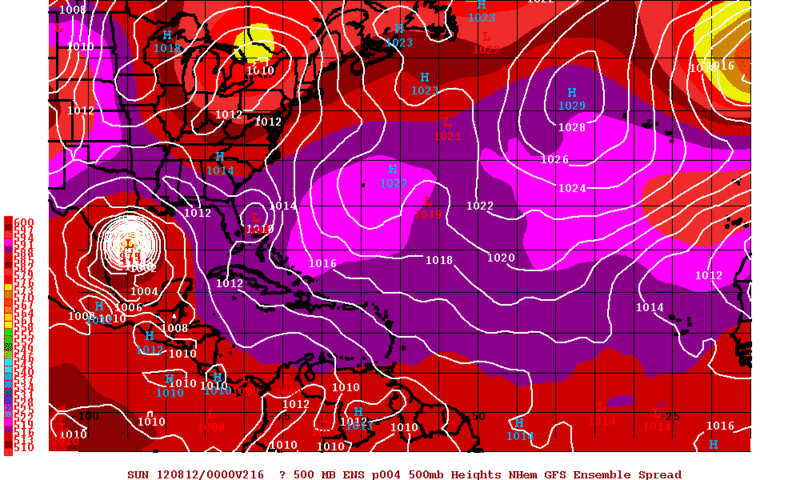
Taking a look at the latest guidance-the models are having a hard time agreeing on the strength of Ernesto which will play a pretty big role in which path Ernesto takes. This image below is GFS Ensemble 4 which is one of the most intense solutions. It paints a picture of Hurricane Ernesto slamming into the Texas Coast. Keep in mind this is only a model run and should be used that way. These models can flip flop every run-just like politicians.
This is the spaghetti plot which shows the path that the models are projecting. Notice the models agree upon a similar path over the next 48 hours.

Here are my thoughts on a possible path for Ernesto which I
believe will become a Hurricane in the Gulf of Mexico.
I'm leaning towards a Texas/northern Mexico impact
at this point. This is an educated guess and the whole Gulf
of Mexico needs to closely watch Ernesto.


If Ernesto follows my projected path,
parts of Texas-possibly Oklahoma will see some heat and drought relief
by next weekend. I know many people are praying and thinking good
thoughts for this to happen because we need the rain. Let's hope no
major damage is cause by Ernesto-no matter which path it takes.
No let's take a quick look at
Invest 90L which has developed in the eastern Atlantic. This wave has
developed some intense convection and if it can sustain itself then slow
organization could occur which could lead to this system developing
into a Tropical Storm over the next few days. The NHC has given this
system a 30% of tropical development.

We will have updates over the next several
days. Please note this forecast and these opinions are that of
www.primoweather.com and not the NHC. For official information please
see http://www.nhc.noaa.gov/
No comments:
Post a Comment