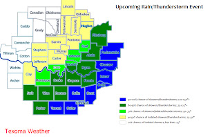
A strong low will move into Texas early Tuesday morning aiding in a chance of showers and thunderstorms for parts of north Texas and southern Oklahoma; at the same time a weak cold front will move into extreme southeastern Oklahoma and northeastern/north-central Texas. As the low moves across Texas, it will interact with the front and enhance rainfall along the front. Determining where the front will be is the main question because that's where the heaviest rainfall will occur. Right now I believe the front will be located just east of HWY 75 and near I-20. Some isolated areas near the front could pick up near 3.00" of rainfall.
Showers and thunderstorms will begin as early as tomorrow afternoon. There will be some strong thunderstorms in the area as the low moves overhead; most of the storms in north Texas should stay below severe levels, however, a few could become severe especially in central/south Texas.
Moisture is surging northward tonight as the upper level low, currently near the Baja of California, heads in our direction.
Chilly air continues to look like a possibility for the area late next week, around or slightly after Thanksgiving; more precip is possible too!


No comments:
Post a Comment