Happy New Year's Eve, Texoma Weather followers! Today is going to be unseasonably warm with temperatures in the mid to upper 70's! Don't let these warm temperatures fool you, though, because a strong cold front is headed our way and will drop temperatures into the 30's and 40's just in time to ring in the new year; not to mention frigid windchill readings. Here's the forecast for a few cities in Texoma:
Oklahoma City/Norman: 6pm-59, 9pm-44, 12am-38(windchill in the 20's), 3am-34(windchill in the 20's)
Dallas/Fort Worth: 6pm-68, 9pm-64, 12am-51(windchill in the 40's), 3am-42(windchill in the 30's)
Tulsa: 6pm-58, 9pm-45, 12am-40(windchill in the 30's), 3am-36(windchill in the 20's)
Sherman/Denison/Durant: 6pm-60, 9pm-57, 12am-49(windchill in the 30's), 3am-43(windchill in the 30's)
Ardmore/Gainesville: 6pm-60, 9pm-50, 12am-44(windchill in the 30's), 3am-41(windchill in the 30's)
That's the hourly forecast for a few cities in our area. Enjoy the warm weather this afternoon and be careful with fireworks, or any other source of ignition; the windy conditions can spread fires rapidly. May your family and you have a safe and blessed new year!
What was the biggest weather event in our area during 2011?
Saturday, December 31, 2011
Friday, December 30, 2011
Are We Still In A Drought?
2011 featured several extreme weather events and patterns across the United States. The drought in the Southern Plains was one of those extreme patterns, and one of costliest too. Luckily this Fall/Winter season so far has been very wet which has helped the drought conditions vastly improve. Here is a look at the latest drought monitor for our region.
The southern jet stream, which has aided in several rain events, has temporarily relaxed, but should become active again in mid to late January. The above average rainfall we've received so far aligns well with Texoma Weather's Fall/Winter forecast.

The southern jet stream, which has aided in several rain events, has temporarily relaxed, but should become active again in mid to late January. The above average rainfall we've received so far aligns well with Texoma Weather's Fall/Winter forecast.
The Warm Weather Won't Last Long!
Enjoy today and tomorrow's warm weather because it will abruptly change late tomorrow night! A stiff cold front will move south tomorrow just in time for New Year's Eve celebrations in Oklahoma City and near midnight, or slightly after, in Dallas. Temperatures will fall from the upper 60's, Saturday, to the 30's early Sunday morning with a stiff north wind. We will feel the impacts from this front through Wednesday; highs will likely be in the 40's in southern Oklahoma, and the Red River Counties of north Texas, while the rest of north Texas will be close to 50. Overnight lows will be knocked down into the 20's Sunday night and Monday night, however, some upper teens will be possible across southern Oklahoma. The forecast should be relatively dry over the next several days. Some showers will accompany the front in our extreme southeastern counties very early Sunday morning. Next Wednesday one model is hinting at some precipitation, but it's still too early to determine if that'll come to fruition.

Don't forget to vote for the biggest weather event in our area during 2011. (Here's an awesome graphic from the Norman National Weather Service.)

Texoma Weather has some big announcements to make during the beginning of 2012! I hope you all have an amazing 2012! Please spread the word about Texoma Weather.
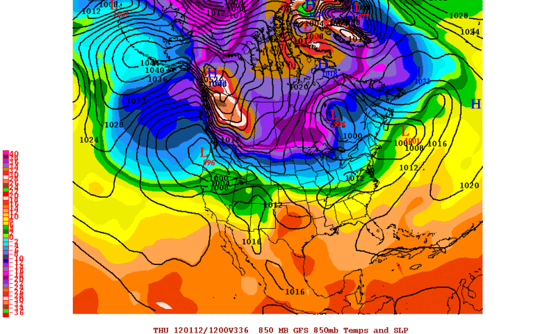
(Some very cold air is building over Alaska, and will be build over western Canada in the near future. Once there is a "buckle" in the jet stream this air will eventually head south.)


Don't forget to vote for the biggest weather event in our area during 2011. (Here's an awesome graphic from the Norman National Weather Service.)

Texoma Weather has some big announcements to make during the beginning of 2012! I hope you all have an amazing 2012! Please spread the word about Texoma Weather.
(Some very cold air is building over Alaska, and will be build over western Canada in the near future. Once there is a "buckle" in the jet stream this air will eventually head south.)

Tuesday, December 27, 2011
Enjoy This Mild Weather! Blue Norther On The Way?
The last few days of December will feature beautiful weather with mild days and cool nights, however, don't get used to this because a full latitude trough could develop which would usher in a much colder air mass.
Right now the models are split on the extended pattern, but a few reliable models are showing this pattern change to ring in the new year. The ECMWF has been advertising this trough for a couple days now and now the CMC is joining in on this solution too. (The GFS, which has been very unreliable as of late, is showing a front moving through, but not nowhere near the magnitude of the ECMWF. The 18ZGFS does show a stronger push of arctic air towards the end of next week.) If the ECMWF is correct the blue norther would blow through Texoma Sunday bringing in very chilly air, not record breaking cold, but still very cold. Highs would likely be in the 30's with lows in the upper teens Sunday through Tuesday. The forecast should be dry with the exception of showers/isolated thunderstorms accompanying the passing frontal boundary; precip behind the front is questionable, but at this time I think the moisture will move out of the area quickly, thus leaving the forecast dry. With that being said it's easy for weak systems to move overhead, with cold air masses in place, and squeeze out what little moisture remains in the atmosphere. I will keep an eye on the evolution of this system and continue to update you all as confidence grows. This blue norther isn't set in stone by any means, but confidence is growing in this arctic air surging south. The 00Z models tonight will be very important as to whether the GFS joins the ECMWF, and to see if the ECMWF continues its blue norther solution.

Right now the models are split on the extended pattern, but a few reliable models are showing this pattern change to ring in the new year. The ECMWF has been advertising this trough for a couple days now and now the CMC is joining in on this solution too. (The GFS, which has been very unreliable as of late, is showing a front moving through, but not nowhere near the magnitude of the ECMWF. The 18ZGFS does show a stronger push of arctic air towards the end of next week.) If the ECMWF is correct the blue norther would blow through Texoma Sunday bringing in very chilly air, not record breaking cold, but still very cold. Highs would likely be in the 30's with lows in the upper teens Sunday through Tuesday. The forecast should be dry with the exception of showers/isolated thunderstorms accompanying the passing frontal boundary; precip behind the front is questionable, but at this time I think the moisture will move out of the area quickly, thus leaving the forecast dry. With that being said it's easy for weak systems to move overhead, with cold air masses in place, and squeeze out what little moisture remains in the atmosphere. I will keep an eye on the evolution of this system and continue to update you all as confidence grows. This blue norther isn't set in stone by any means, but confidence is growing in this arctic air surging south. The 00Z models tonight will be very important as to whether the GFS joins the ECMWF, and to see if the ECMWF continues its blue norther solution.
Sunday, December 25, 2011
Merry Christmas! Where's the snow?
Good Afternoon, I hope everybody is having a fantastic Christmas! The cutoff low that was supposed to move across Texoma Saturday actually stalled, then retrograded to the west. This erratic movement is what reduced our chances of snow this weekend. If the system would have moved overhead the temperatures aloft would have been cold enough for a light dusting of snow. Yesterday several areas did receive sleet throughout the day, but the temperatures at the surface were too warm and the precipitation wasn't heavy enough for any accumulations. Parts of west Texas and the Panhandle, however, did have cold enough temperatures, where the low was located, and in return are enjoying a white Christmas. Picture--Courtesy James Hale
The low is currently located near the Panhandle of Texas and is cutoff from the main flow, but will eventually begin to move eastward tonight. Here are the snow totals from the Lubbock region; these totals prove how potent this system is.

As the low moves overhead tomorrow evening/overnight there will be some precipitation developing. Most of this precip will be rain, but on the backside a well developed trowal could come to fruition per models. If this were to happen some parts of southeastern Oklahoma and northeast Texas could see a light rain/snow mix. I'm waiting for the 18Z models to come in then I'll have an update on the possibility of the trowal development and its implications on the forecast.
The low is currently located near the Panhandle of Texas and is cutoff from the main flow, but will eventually begin to move eastward tonight. Here are the snow totals from the Lubbock region; these totals prove how potent this system is.
As the low moves overhead tomorrow evening/overnight there will be some precipitation developing. Most of this precip will be rain, but on the backside a well developed trowal could come to fruition per models. If this were to happen some parts of southeastern Oklahoma and northeast Texas could see a light rain/snow mix. I'm waiting for the 18Z models to come in then I'll have an update on the possibility of the trowal development and its implications on the forecast.
Subscribe to:
Comments (Atom)
