 The dew-points have been on the rise since a warm front moved north last night, so there's plenty of moisture for thunderstorms today; shear is also in place today. With the high moisture content expect some very heavy downpours with thunderstorms.
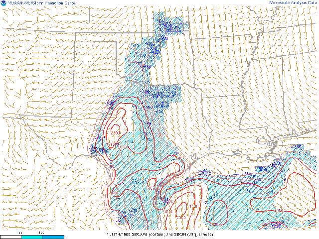
 The limiting factors are: meager instability, due to thick clouds, and a cap, which will eventually begin to erode this afternoon. What's interesting is the latest NAM shows the atmosphere destabilizing this afternoon, even with the thick cloud-cover, with 1000J/KG CAPE. Here's the latest surface based CAPE, which is pretty impressive in Central Texas.
Even with the cap, which will slowly erode, and the thick clouds, limiting instability, I believe thunderstorms will develop, some becoming surface based, and move west to east across our area; I think the NAM has the right scenario for the thunderstorm evolution. A few storms this afternoon will be strong and a couple surface based ones could reach severe levels with large hail and damaging winds. Here's the area that the Storm Prediction Center has highlighted for today.
This is a developing situation and if more instability were to come into play the forecast would need to be altered. I will continue to monitor the latest trends and conditions, and post updates on the "Texoma Weather" Facebook page as needed. We will have an update, soon, on Thursday's rain potential and the next storm system that will impact us early next week. The models are starting to paint a clearer picture of the system; the track is crucial in forecasting precip type and temperatures on the back side of this system. There are indications that an impressive deformation band will form on the back side of the low dropping snowfall in its path. (That's why the track is so important; a northerly track would mean we would likely miss out on snow, but a southerly track could incorporate our area into the "fun and games!" I'm thinking the southerly track is more realistic, at this time. There are still several days to track this system and several days for a changing forecast.)


No comments:
Post a Comment