Good Friday evening everybody,
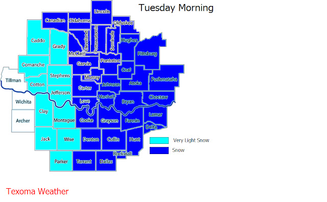
Over the past several days we've been forecasting the possibility of wintery precipitation in Texoma, and today that possibility has increased with several models jumping on-board. A strong cold front, arctic in nature, will move through Texoma Saturday night(NW) into Sunday morning(SE). Accompanying the front will be dropping temperatures and an increased threat of precipitation. The increase in precip is from a low that will be in Arizona heading east towards our area. While there are still many uncertainties with this system, speed/track/moisture/temperatures, the details will become clearer over the next 24-36 hours. I'm confident that most of our area, if not all of it, will see some type of wintery precip over the course of Sunday-Tuesday; amounts and types are still questionable at this time. I do urge people to prepare for this possible winter storm because the roads could get bad, especially in the northwestern parts of the area; The low sun angle, this time of the year, and the cold temps moving in behind this system could make roads treacherous! This is not set in stone, but I do believe we could have a direct impact from this winter storm. Stay tuned to Texoma Weather for the latest updates on this evolving system, as one slight change can be the difference between a major winter storm or a cold rain event. Here's a preliminary outlook for the area..again this will likely change as we get closer to the event.
This forecast goes well with what Texoma Weather predicted for this upcoming season. If you've yet to check out our winter forecast, please do so. It's going to be a wild ride!


No comments:
Post a Comment